Monday, May 31, 2010

Big (Part 2)

Alaska is the size of:
114 Connecticuts,
277 Delawares,
88 Hawaiis,
69 Massachusetts,
61 New Hamphires,
470 Rhode Islands, or
2 Texas.

In fact, if Alaska were to split in half and form two states, Texas would drop from second largest state to third.

Without Alaska, Brazil and Australia are larger than the United States.

Alaska-Canada border: 1,538 miles long

East to West, it is 2,700 miles wide. When a scale map of Alaska is superimposed on a map of the 48 lower states, Alaska extends from coast to coast.


Sunday, May 30, 2010

How Big is Big? (Part 1)

You may have heard that Alaska is a big state. But you might not realize HOW BIG that really is.

There are a number of pictures showing the state of Alaska superimposed on the lower 48. Here is one.


In addition, consider these facts:

  • Alaska's 570,373 square miles is one-fifth the size of the continental U.S.
  • Alaska is more than twice the size of Texas (which prides itself on bigness)
  • It is larger than the combined area of the next three largest states: Texas, California, and Montana
  • It is larger than the combined area of the 22 smallest U.S. states
  • It is also larger than all but 18 sovereign countries!

Saturday, May 29, 2010

Do U Know Juneau?

Juneau is a unique capital city.

The city of 30,000 is located is located 900 air miles north of Seattle and 600 air miles southeast of Anchorage. That makes it (by far!) the capital located the furthest from the most populous city.


Juneau is:

  • Larger in area than the state of Delaware in area
  • The U.S. state capital whose namesake was most recently alive: Joe Juneau died in 1899, a year after Otto von Bismarck (North Dakota).
  • The only state capital with no roads connecting it to the rest of the state
  • The only U.S. state capital to border another country - it shares its eastern border with the Canadian province of British Columbia.. (Carson City, Nevada and Trenton, New Jersey are the only state capitals which border another state.)

Friday, May 28, 2010

A day and a half

Nothing to do with Alaska, but my favorite countdown at the moment.

Also Known As

Our cruise takes us through Alaska's Inside Passage.

The Inside Passage is also known as:

  • Southeast Alaska
  • The Panhandle
  • The Inland Passage

The Alaska Inside Passage extends 500 miles from north to south and 100 miles from east to west. The area encompasses 1,000 islands, 15,000 miles of shoreline and thousands of coves and bays.


Inside Passage - Southern Region
Includes Ketchikan (our stop), Wrangell, and Petersburg.

Review for the quiz - Ketchikan is known for:
  • Fishing industry
  • Totem pole collections
  • Rain!


Inside Passage - Northern Region
Includes Juneau (our first port), Skagway (our second port), Sitka and Haines.

  • Juneau is the state capitol and home of Mendenhall Glacier.
  • Skagway is famous for its role in the Yukon Gold Rush.


Alaska State Capitol, originally built as a federal office building in 1931
. Not terribly attractive!


Inside Passage - Glacier Bay

Glacier Bay is a National Park and an area all its own, filled with spectacular scenery and wildlife. We spend an entire day cruising Glacier Bay.


Thursday, May 27, 2010

Wednesday, May 26, 2010

NSFAQ

These were really good, so had to continue a bit of yesterday's theme.


Not-So-Frequentl
y-Asked Questions (about Chicken, Alaska)

Q. We will be visiting Alaska in June is there a place we would either hook up our motor home to or a place for us to shower etc.? Barb Hulst Zeeland, Michigan

A. Yes, we call this place "Fairbanks."


Q. How far is it to Toronto from there? Pat Cunliffe, West Vancouver, BC, Canada

A. I don't know, but I'm asked that all the time. Pretty far I imagine.


Q. I am worried that if we move to Chicken, my children will have to marry each other. What are your laws about inbreeding? Jennifer, VA Beach

A. Jennifer, have you considered how convenient it would be to look for dates right at your family reunion?


Q. We passed through the thriving metropolis of Chicken in 1995 and we were very impressed. What we want to know is , if we decide to come through again in a couple of years, will Chicken be so crowded that you would recommend reservations far ahead of time for food and gas services? -Karen and Dave Sandeman, Calgary, Alberta

A. Good question Karen and Dave. What with the Olympics, the World's Fair, and the Calgary Stampede seriously considering Chicken as their new location, you may want to call ahead - as soon as we get phones.


Q. Will the citizens of Chicken, Alaska be able to see Star Wars New Edition? -Frank Geary, Pottstown, PA

A. Most of the citizens of Chicken have yet to see the original release.


Q. Does everybody in Chicken wear that same red flannel shirt? -Jerry Evjen, Silicon Valley

A. Not at the same time.

Tuesday, May 25, 2010

Place Names, Part 4

Grand Prize Winner

This is my all-time favorite Alaska place name!

According to local lore, there was a mining town that sprang up during the Klondike Gold Rush. The miners who settled there wanted to name it Ptarmigan (for the Alaska state bird). However there was just one problem - they didn't know how to spell it!

So (to avoid the embarrassment of a misspelling) they instead named it.....CHICKEN!

Chicken still exists today (population 17) and has a bar, gift shop, cafe, salmon bake, and post office.


.


Chicken also boasts its own website (promoting tourism) and features directions, maps, history, and some inquisitive and humorous FAQs!


Frequently Asked Questions:


Q: Is there any electricity in Chicken?
A: Nope. Most people use generators.

Q: Well then what about phones? Huh?
A: Nope, no phones either. That means no Internet access for those that can imagine the possibility. The website is maintained outside of Chicken.

Q: What about mail?
A: What about it?

Q: Do you get any?
A: Yes, mail arrives by plane Tuesdays and Fridays of every week. Chicken has had continual mail service since 1906


Q:
Okay. So, where are the bathrooms?
A: Chicken has no central plumbing. But you're welcome to use the outhouse.


Monday, May 24, 2010

Place Names, Part 3

El Presidente

Near and dear to this blogger's heart, it was nice to see that Alaska did not forget the U.S. presidents when naming their cities, lakes, mountains, and streams. Here is a sample I found.

Cleveland Peninsula, near Ketchikan - Named in 1886 by U.S. Coast and Geodetic Survey for Grover Cleveland (who was serving his first term in office at the time)

Lincoln Rock and Abraham Islands - Named in 1886 by Lieutenant Commander A. S. Snow, U.S. Navy, for Abraham Lincoln

Jefferson Peak (94 mi. E of Sitka) - named in 1887 by Lt. Commander C. M. Thomas, U.S. Navy, for Thomas Jefferson


Roo
sevelt Lagoon (near Ketchikan) - Local navigators' name obtained in 1904 by H. C. Fassett, U.S. Bureau of Fisheries; named for Theodore Roosevelt


Mt. Harding (near Skagway) - Named in 1924 by the Skagway Alpine Club for Warren Gamaliel Harding (1865-1923), 29th president of the United States who visited Skagway in 1923.


Mt. McKinley
- The highest peak in North America was originally named Denali ("The High One") by native peoples.


Denali was renamed Mount McKinley for William McKinley, a nominee for president, by the Princeton graduate and gold prospector, William Dickey. Dickey was one of the hundreds of prospectors seeking gold in the 1896 Cook Inlet stampede. The naming has been described as "politically driven." (Did we mention that this was an election year?)

It seems that presidential candidate William Jennings Bryan favored a silver standard for currency, while McKinley favored the gold standard. Dickey met many silver miners who were Bryan proponents (and quite vocal about it), so the naming (for the gold standard champion) was retaliation.

In the 1970s there was a movement to get the mountain's original name restored, but this was met with resistance by Ohio congressional representatives (McKinley's home state). A compromise was to rename the national park (containing the mountain) to Denali National Park, while the mountain keeps the name of the president.

Sunday, May 23, 2010

Place Names, Part 2

A few more places with interesting origins.

Bean Creek — Supposedly, this stream, which empties into the Kenai River just below the outlet of Kenai Lake, was named in the mid-1930s when a group of men building the first Kenai River bridge was encamped along the creek and found themselves with nothing to eat but beans.


Resurrection Bay is a bay on the Kenai Peninsula. It received its name from Alexandr Baranov (Russian fur trader), who was forced to retreat into the bay during a bad storm in the Gulf of Alaska. When the storm settled it was Easter Sunday, so the bay and nearby Resurrection River were named in honor of it.


Resurrection Bay


Coldfoot primarily serves as a truck stop on the Dalton Highway from Fairbanks to Prudhoe Bay. It has a restaurant and a small number of overnight accommodations (converted pipeline construction camp quarters). Bus tours along the highway typically take two days with passengers spending the night in Coldfoot.


The town was originally a mining camp named Slate Creek, and around 1900 got its present name when prospectors going up the nearby Koyukuk River would get "cold feet" and turn around. In 1902 Coldfoot had two roadhouses, two stores, seven saloons, and a gambling house. A post office operated from 1902 to 1912, then reopened in 1984.

North Pole is a city 13 miles to the southeast of Fairbanks. Despite the name, the city is about 1,700 miles south of Earth's geographic North Pole.

The area that is now North Pole was homesteaded in 1944 by Bon V. Davis. A development company later purchased the Davis homestead, subdivided it, and named it North Pole, in hopes of attracting a toy manufacturer to the area. The City of North Pole was incorporated on January 15, 1953.


The city is a summertime attraction for tourists visiting nearby Fairbanks, and traveling to and from the Alaska Highway and Valdez. Its biggest attraction is a gift shop named Santa Claus House with the world's largest fiberglass statue of Santa Claus outside. Prior to Christmas each year, the USPS post office in North Pole receives hundreds of thousands of letters to Santa Claus, and thousands more from people wanting the town's postmark on their Christmas greeting cards to their families. It advertises the ZIP code 99705 as the ZIP code of Santa.


Christmas-themed streets in North Pole include Santa Claus Lane, St. Nicholas Drive, Snowman Lane, and Kris Kringle Drive. Street lights in the city are decorated in a candy cane motif, and many local businesses have similar decorations.

Saturday, May 22, 2010

Place Names, Part 1

Some of the more "interesting" place names in Alaska:

Point Seduction (located in the Lynn Canal, near Skagway)- Named for the "artful character of the Indians" in trying to persuade Joseph Whidbey (British expedition leader) to stay longer.


Nome - Cape Nome (near the city) received its name from an error, when a mapmaker copied a map annotation made by a British officer on a voyage up the Bering Strait. The officer had written "? Name" next to the unnamed cape. The mapmaker misread the annotation as "C. Nome", or Cape Nome, and used that name on his map.


Ford's Terror
(steep and narrow fjord 60 miles southeast of Juneau in Alaska's Inside Passage) - named after a U.S. Navy crewman named Ford who, in 1889, paddled into the narrow waterway at slack tide. The tide began to rise, forcing its way through the bottleneck entrance into the fjord, and Ford was trapped in the turbulent currents (surrounded by massive, crashing icebergs)for the next "terrifying" six hours.


Port Lions (city on Kodiak Island) - Built to house the inhabitants of Ag'waneq from the neighboring island of Afognak and Port Wakefield from Raspberry Island, after their villages were destroyed by the Good Friday Earthquake in 1964. Port Lions was built with help from the U.S. government and the Lions Club. It was named in honor of the club.


Port Lions post office


Unalaska
(city in the Aleutian Islands) - No, they DON'T think the rest of the state is uncool!


The native Unangan people, who were the first to inhabit the island of Unalaska, named it “Ounalashka” meaning ‘Near the Peninsula’. The name Unalaska is probably an English variation of this name.

Friday, May 21, 2010

Natural Phenomena - Part 3

Natural Phenomena - Aurora Borealis

The Aurora Borealis, or Northern Lights, are seen frequently in Alaska as well as other northern latitudes.

The Aurora Borealis can be described as shimmering curtains of light that flutter across the sky.

When charged electrons and protons - released during sunspot activity - drift toward the earth, they are magnetically pulled to the northern and southern latitudes. These charged particles collide with gases in the earth's upper atmosphere and turn luminous - ranging from silvery white through the colors of the rainbow.


The Aurora Borealis is most prevalent over the Arctic Circle but can occur throughout the northern latitudes. The "Northern Lights", at their most dazzling from December to March when nights are longest and the sky darkest.

Quote: "Hardy Alaskans like to put on their parkas and lie on their backs in the snow to watch."


Fairbanks and Chena Hot Springs are popular viewing locations, and there are even "Northern Lights Viewing" tours - though the lights themselves are fairly unpredictable!

Thursday, May 20, 2010

Natural Phenomena - Part 2

Natural Phenomena - Geothermal Features

Alaska is rich with geothermal features such as volcanoes, fumaroles (steam pots), and hot springs.


Vocanoes

There are approximately 500 active volcanoes in the world; 70 of these are located in Alaska.

Most all of Alaska's volcanoes are located along the 1,500 mile Aleutian Arc that extends westward to Kamchatka and forms the northern part of the Pacific Ring of Fire.

According to the U.S. Geological Survey, the largest eruption on Earth in the 20th Century occurred in Alaska at Novarupta Volcano, near Mount Katmai, in June 1912. The eruption created the Katmai Caldera and the Valley of Ten Thousand Smokes. Volcanic ash, more than from all other historical eruptions in Alaska combined, devastated areas hundreds of miles away.

Alaska's most recent significant eruption was Redoubt, in March 2009. It sent plumes of smoke and ash about 9.5 miles into the sky and caused flight cancellations.


Major eruptions along the Aleutian Arc occur almost every year. However, eruptions in unpopulated areas often go unnoticed by everyone except those who study volcanoes.

Volcanoes also exist beneath the ocean's surface and are called seamounts. About 100 of these extend from the Gulf of Alaska to the Oregon coast.

Fumaroles

A fumarole (Latin fumus, smoke) is an opening in the earth's crust, often in the neighborhood of volcanoes, which emits steam and gases.

The Valley of Ten Thousand Smokes, which was formed during the 1912 eruption of Novarupta in Alaska, provides a classic example of fumaroles. Initially, there were thousands of fumaroles in the cooling ash from the eruption, but over time most of them have become extinct.

Fumaroles escape through Fourpeaked Glacier covering Fourpeaked Volcano in Alaska on September 24, 2006


There are also an estimated four thousand fumaroles within the boundaries of Yellowstone National Park. (JHAWK note: have also seen these in Iceland - another land of volcanoes - and at California's volcanic Mt. Lassen.)

Hot Springs

Hot springs are produced by the emergence of geothermally heated groundwater from the Earth's crust. (They are often heated by the same sources that produce the volcanoes and fumaroles.)

In active volcanic zones such as Yellowstone, water may be heated by coming into contact with magma (molten rock). The high temperature gradient near magma may cause water to be heated enough that it boils or becomes superheated. If the water becomes so hot that it builds steam pressure and erupts in a jet above the surface of the Earth, it produces a geyser.

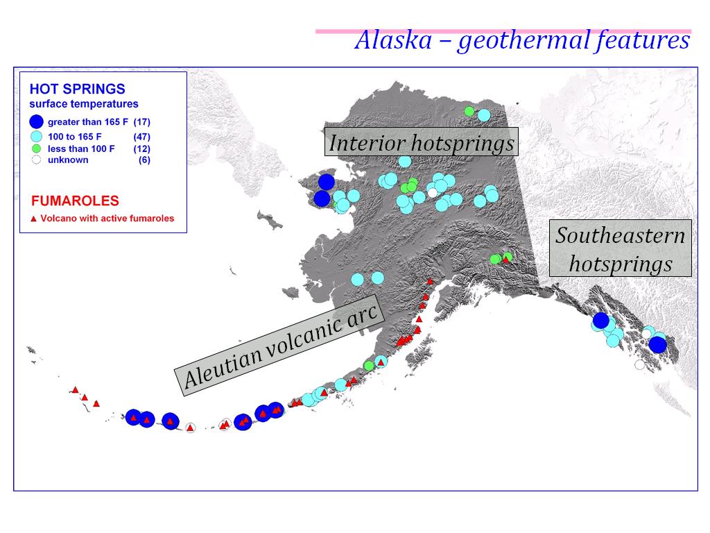
Several hot springs exist in Alaska. (See map above)
The most famous of these is Chena Hot Springs, located in Alaska's interior about 60 miles from Fairbanks.

Wednesday, May 19, 2010

1-1-1

One month, one week, and one day.

North to Alaska!

Natural Phenomena - Part 1

Alaska Natural Phenomena - Earthquakes

Alaska sits at the intersection of the Pacific plate and the North American plate, making it a prime spot for earthquake activity.

Alaska Earthquake Statistics:

  • The largest magnitude earthquake in the U.S. (9.2) occurred in Alaska in 1964; the epicenter was in Prince William Sound about 90 miles south of Anchorage; many Alaska towns were devastated by either the earthquake or the tsunamis that followed
  • By contrast, the famous San Francisco earthquake of 1906 was a 7.8 magnitude; however this and other earthquakes caused more loss of property and injury due to occurring in populated areas
  • 9 of the top 10 (and 15 of the top 20) earthquakes in the U.S. have been in Alaska
  • There are an average of 50-100 earthquakes in Alaska daily!
  • Alaska Earthquake Information Center locates and report about 22,000 earthquakes each year
Prince William Sound 1964 Earthquake:

Tuesday, May 18, 2010

Ketchikan Revisited

Ketchikan visitor to child:
"How long has it been raining?"

Child:
"I don't know; I'm only five."

Monday, May 17, 2010

Polar Pun

Q: Why are polar bears big and furry?
A: Because if they were small and smooth, they'd be aspirins.

Sunday, May 16, 2010

Save Room for Shopping

Nice little video from a store that is located by the docks in Ketchikan. (Nice history as well.)


http://alaska.org/videos/tongass_trading_video.htm?Tongass_Trading_wide3FL8.flv

"From t-shirts to Totem poles!"
I actually could do all my souvenir shopping now at their online shore!

Photo circa 1907:


Note: I think they sell those boots featured yesterday! :)

Saturday, May 15, 2010

Ketchikan Featured Product

Remember that Ketchikan is the rain capital of Alaska!

Friday, May 14, 2010

Totem Poles, Part 3

Totem Poles in and around Ketchikan

Ketchikan offers several opportunities for viewing totem poles.

Totem Bight State Park features 18 totem poles and a Clan House built by Alaska Native artists in the 1920s.


Saxman Nat
ive Village includes totem poles (some over 100 years old), a traditional Beaver Clan House where Alaska Natives would have lived and celebrated, and a carving shed.


The Totem Heritage Center preserves endangered 19th century totem poles retrieved from uninhabited Tlingit and Haida village sites near Ketchikan. These original poles are displayed at the Center in conjunction with other totems and Native Alaskan artifacts.


Totems can also be viewed at other public locations around town, and even in front of local residences.

Thursday, May 13, 2010

Totem Poles, Part 2

Captain James Cook was among the first Europeans to see the magnificent Northwest signpost, the totem pole. Unlike most newcomers, he had a rare appreciation for native art, and did not condemn it as "pagan." He believed them to be images of ancestors "whom they venerate as divinities," coming close to the truth.

Essentially the totem is a legal document in the woods. It reminds residents of legends, great chiefs, clan lineage, and claimed territory.

Totems were traditionally made from red cedar and carved with tools of stone, shell, beaver tooth, and jade. The art of the totem peaked in the 1800s when steel tools were introduced and the wealth from fur trading urged chiefs to compete in commissioning totems.

Differences by Tribal Group


Tsimshi
an poles are known for their sense of scale and proportion, precision, and sculptural technique. Details are rendered in low relief rather than by surface lines. Color is used sparingly. Crests include the sea bear and whale.


Haida poles use deeply cut, unpainted, dramatic forms that overlap and interlock. Haida crests include the seal, eagle, killer whale, and frog. Figures are static, as though freeze-framed.


Tlingit poles show a series of separated, superimposed, realistic forms. A watchman figure or clan crest may be placed on the top. Attached, projecting pieces such as an eagle's wings or a raven's beak are signature devices. Figures are dynamic, portrayed climbing, sticking out a tongue, or flying. Color is used extensively - traditionally black, blue-green, red, and yellow.


The rest of America first saw totem poles during the Centennial Exhibition in Philadelphia in 1876.

1876 exhibition photo with totem on far left